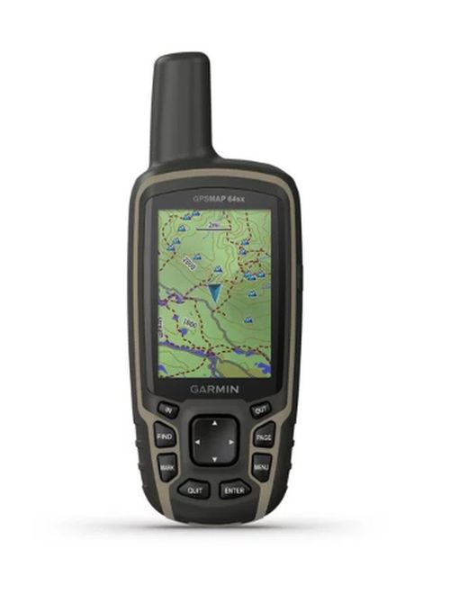
Garmin GPS Map 64x GPS
Brand: Garmin
Reference: 010-02258-01
€306.19
Product sold out, not available at this time.
Next stock entry on the way, expected
Description
Garmin renews the historic high-precision GPS Map series with its new 64x and 64sx GPSmap models. The high precision antenna, the large memory capacity and the connectivity via ANT + and Bluetooth are its great assets.
Details
More information
The Garmin GPS Map 64sx GPS is a highly sensitive handheld device for high mountains and remote or hard-to-reach places. The Quadrifilar Helix antenna and the possibility of GPS, GLONASS and Galileo reception make it the most accurate device on the market.
It has the 2.6 "(6.6cm) and 3.6 x 5.5cm full color transflective screen . The operation with buttons allows use in adverse conditions, wearing gloves or other elements, typical for high mountains.
It has an 8GB internal memory and preloaded maps , with the possibility of adding more cartography or satellite images. Memory can always be expanded with a MicroSD card . The autonomy of the battery is 16 hours and works with two AA batteries.
In addition, with ANT + and Bluetooth connectivity, you can synchronize this GPS with other Garmin equipment to complete a wide range of functions.
Characteristics:
- UNIT DIMENSIONS (WIDTH / HEIGHT / DEPTH): 6.1 x 16.0 x 3.6 cm
- SCREEN SIZE (WIDTH / HEIGHT): 3.6 x 5.5 cm; 6.6 cm diagonal (2.6 ")
- SCREEN RESOLUTION (WIDTH / HIGH): 160 x 240 pixels
- SCREEN TYPE: 65,000-color transflective TFT
- WEIGHT: 230 g with batteries
- BATTERY 2 AA batteries (not included); NiMH or lithium recommended
- BATTERY / BATTERY AUTONOMY: 16 hours
- WATER RESISTANCE RATING: IPX7
- MEMORY / HISTORY: 8 GB
- HIGH SENSITIVITY RECEIVER: Yes
- EQUIPMENT INTERFACE: Compatible with high speed USB and NMEA 0183
- POSSIBILITY TO ADD MAPS: Yes
- BASE MAP: Yes
- STORAGE AND CHARGE CAPACITY: microSD ™ card (not included)
- WAYPOINTS: 5,000
- ROUTES: 200
- TRACKS: 10,000 points, 200 saved tracks
- BAROMETRIC ALTIMETER: No
- COMPASS No
- AREA CALCULATION: Yes
- AUTOMATIC ROUTE CREATION (ROAD TURN TO ROAD) Yes (with optional maps with detailed road information)
- GEOCACHING MODE Yes (paperless)
- COMPATIBLE WITH CUSTOM MAPS: Yes
- HUNTING AND FISHING CALENDAR: Yes
- ASTRONOMIC INFORMATION: Yes
- IMAGE VIEWER: Yes
- Garmin Connect ™
- COMPATIBLE WITH GARMIN CONNECT ™ (ONLINE COMMUNITY IN WHICH YOU CAN ANALYZE, CLASSIFY AND SHARE DATA)
- GPS: yes
- GLONASS: Yes
- Galileo: yes
- Wireless Compatibility: Yes (Bluetooth® and ANT®)
- Smart notifications: Yes
- Real-time tracking: Yes (with Garmin Connect ™ Mobile)
Comments
There are no opinions yet Be the first to review!
Questions
No questions yet Do you have any doubt?
Best price
Have you seen it cheaper?
